Why the natives lost their Status and Rights, Land Rights
DAP and PKR kinda gotten these lands within their circle of cronies, not forgetting Ajib of course.
Raymond H.H Tan
This chapter is very much complicated and it’s more than a century old. It involves land rights and natives’ status but what I will be highlighting is my presumption on what’s really the fuzz behind these cover ups for decades, hence the conspiracy on what’s left unexplained in regards to the so called “Special Privileges”.
When I first started researching the Temuan tribes at Kampung Pulau Kempas, I was tracing a file titled ‘Bil 279’. It was mentioned throughout government’s establishment but for whatever reasons the file went completely missing in all departments including the National Archives and Printing Departments. I then asked a friend to help trace it from the Colonial Office in UK, and the feedback given from a well known professor was “that’s funny, how on earth did the entire file “managed to vanish?”. Well, apparently this was the only file that went missing counting on sequels from file 001 to 999, but only File 279 was nowhere to be seen.
So, with not many documents to trace with, I then went back to Juru Permetaan Malaysia (JUPEM) with a gazette issued during the British ruling era in year 1927, known as FMS ‘Government Gazette 2578’ (Federal Malayan States). But to my amazement, when I located the 1927 Book of Gazette, it too was partially damaged. What I meant by partially damaged is that the Gazette 2578 page itself was in crumbled pieces as the paper tends to break like a biscuit since it is decades old. In that frustrated sense it was very obvious to say that some idiot intentionally got that page wiped-crunched by hand.
Anyway, for years I know there’s a cover up on this particular District. Initially, I thought it has only something to do with article 153 or the status of the natives being the reason for sabotage, but I was only partially right because File 279 is not just about all that, but, there’s something buried underneath! I mean if that’s not the reason for its weird divided boundaries then why not include the entire southern territories instead of a weirdly gazetted zone? There’s no reason not to, since the Mah Meri Tribes of Pulau Carey and the Temuan Tribes of Tanjung Sepat (Orang Laut) are still occupying and residing on this particular region. Set aside its status, the whole gist to it is the way it was gazetted and its boundaries divided – selectively.
Further to some fun detail, Batins always had their settlements built on where Pokok Kempas is sighted. Kempas is of hardwood and they are often seen growing on rich mineral grounds. So, now the question is how big an area is Pulau Kempas, then? To answer that, it was called a Pulau because it protrudes like a sore dick, gunung-like if you will. According to Batin, Pulau Kempas used to be more like a conquered empire. There was also a base named Bukit Komandor, maybe to protect whatever not? Anyway, as currently some politicians have gotten hold of Bukit Komandol, the natives have since shifted into another lot given by the stupid State Government in 2010, gangster threats and unethical police personnel were ordered to assist the shift. Anyway another time for that story, let me just cut to the chase….
Land = Mining = Money = Power = Control….
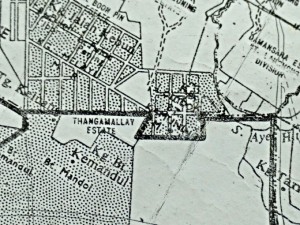
The gazetted area is 17,900 acres. On the northern tip of it sits ‘Thangamalai Estates’, which directly translates to ‘Bukit Emas’. It is also where Bukit Komandol used to be stationed until the Brits relocated them (one of the excuses given by the Brits was that the said estate lot had been leased to an Indian man). There were disputes and arguments back then when defining boundaries as far as this particular estate is concerned. As you can see the map’s bearing is as shown here :-
And this is the current map by Perancang prepared in year 2006, apparently IJM has taken over this estate in preparation for a project called Canal City?
Here’s the problem, I know for a fact that IJM intends to sell the minerals first before development. The said lot bears 1167 acres of the highest grade of fine clay in the country (kowlin), and it is kinda hilly, so how on earth would they have canals on a hill? So in that peaking sense, I am however not sure of its actual value, only by way of a boring test could it be determined. Nevertheless, I was then introduced by (to some) “ex-culprits” of the dredging industry uncles who took me around to survey and said to me, “if can get this piece of land ah, you will be the most famous tanah liat king”, whatever that means, I am sure it is more than just a pitch.
This video link below will clarify as to what is really beneath. This particular mining lot is adjoining Thangamalai Estate and Kampung Lombong, and both are within IJM’s vicinity. It is known as ‘Lombong Dayapi’ which is supposedly to be measuring only about 4-5 acres or so, but operated areas stretches across reserved lands. Here’s the link to the video which shows a collapsed quarry at Lombong Dayapi. You might find the excessive digging weird – that deep for what?
> https://www.youtube.com/
Conclusion is, after having a long discussion with Batin Malam, we concluded that these mining lands hold huge volumes of minerals, let it be sand: red earth, clay, silver, or gold, we have it all. Well … not quite having it all, DAP and PKR kinda gotten these lands within their circle of cronies, not forgetting Ajib of course. Anyway that’s another story for another time. Hidup Selangor….